Riyadh Metro map
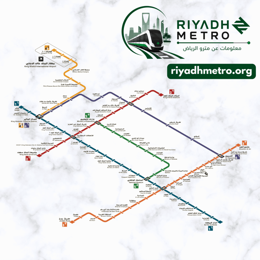
A schematic diagram of the Riyadh Metro — all six lines, 83 stations and every transfer station. View it here or download it as a PDF.
The complete Riyadh Metro network map
A schematic diagram drawn by riyadhmetro.org from the Royal Commission for Riyadh City open data, with the official station names in Arabic and English: Line 1 (Blue), Line 2 (Red), Line 3 (Orange), Line 4 (Yellow), Line 5 (Green) and Line 6 (Purple), 83 stations and the ten transfer stations. It is not to scale and it is not the operator’s official map.
Download the Riyadh Metro map as a PDF
A high-resolution file you can print, or keep on your phone and check offline.
Map key and line colours
Line diagrams — every station
A clickable diagram of each line in station order, with transfer stations and end-of-line stations marked. Tap any station to open its page.
Line 1
Line 1 · SAB Bank ↔ Ad Dar Al Baida
Line 2
Line 2 · King Saud University ↔ King Fahad Sport City
Line 3
Line 3 · Jeddah Road ↔ Khashm Al An
Line 4
Line 4 · KAFD ↔ Airport T1-2
Line 5
Line 5 · Ministry of Education ↔ National Museum
Line 6
Line 6 · KAFD ↔ An Naseem
Service status
Riyadh Metro status
Service status · based on the published timetable
Line 1 (Blue) · SAB Bank ↔ Ad Dar Al Baida
Line 2 (Red) · King Saud University ↔ King Fahad Sport City
Line 3 (Orange) · Jeddah Road ↔ Khashm Al An
Line 4 (Yellow) · KAFD ↔ Airport T1-2
Line 5 (Green) · Ministry of Education ↔ National Museum
Line 6 (Purple) · KAFD ↔ An Naseem